|
September 2010 - Adeii Eechii Cliffs
For a long time it was a kind of secret where the place with the strange red and white sandstone formations could be found - of course only to protect the Natives and the nature from tourists. However, the secret is no longer a secret. When the first reports describing the route to the “secret” place at the Adeii Eechii Cliffs appeared in the web, I decided to visit this place. However, a first attempt in March 2010 failed because I had no car with 4WD. The routes published on the web started in Tuba City and the unpaved road soon became rather sandy. It was too risky to go on without 4WD, in particular at this time of the year when I was not prepared to spend a night in my car if I got stuck.
Planning the trip
Back at home, I sought alternative routes to the Adeii Eechii Cliffs, and came to the conclusion that the shortest way to the Cliffs would start in Cameron and not in Tuba City. I had to go to Cameron in any case to get the necessary permits for traveling and spending the night in the Navajo Reservation.
When planning my trip I was a bit concerned by a report describing an encounter with a rather aggressive Navajo on the way to the Cliffs. The Navajo threatened to puncture tires, among other things, if the visitors would not disappear quickly. Since I was traveling alone, I was not keen of having such an encounter. It was also known from several reports that the house of a Navajo was located near the Cliffs. This could inevitably lead to an encounter with Navajos – something I tried to avoid, if possible. I never experienced any aggressiveness of Navajos on my trips through their reservation however I took the above mentioned report very seriously and sporadically I had heard about similar experiences of travelers in the Navajo Reservation.
The unclear situation about Do’s and Don’ts in the reservations is to a certain extend responsible for such strange encounters. In addition to numerous assumptions, personal experiences, and of course the information from the Navajo Parks and Recreation Department there is always some uncertainty. Hence, for me it was clear that I would contact the respective authorities of the Navajo Reservation to get the necessary permits.
The Navajo Reservation
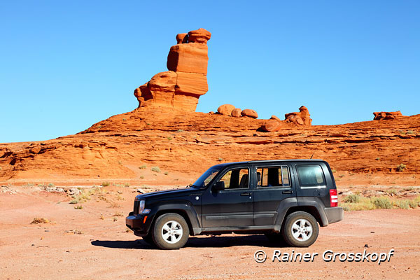
In September 2010 I rented a Jeep Liberty which was well-equipped with 4WD and 4WD low, to take me deep into the Navajo Reservation along unknown and eventually rather sandy roads. The day before I started, I had indeed failed in an attempt to reach Tatahatso Point overlooking the Gooseneck of the Colorado because my GPS waypoints lead me into the middle of nowhere. After an unsuccessful search for alternative routes I gave up. However, this failure inspired me even more to be successful in finding the route to the Adeii Eechii Cliffs.
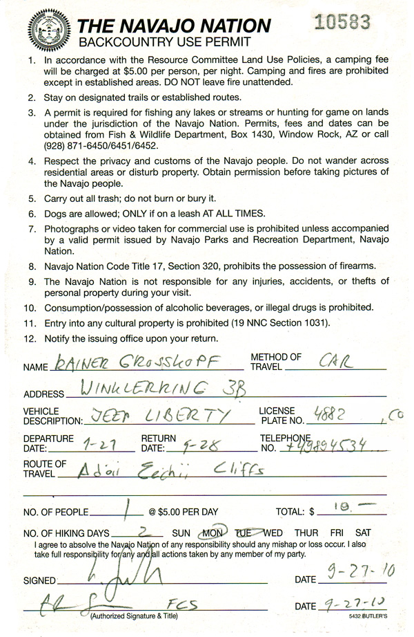
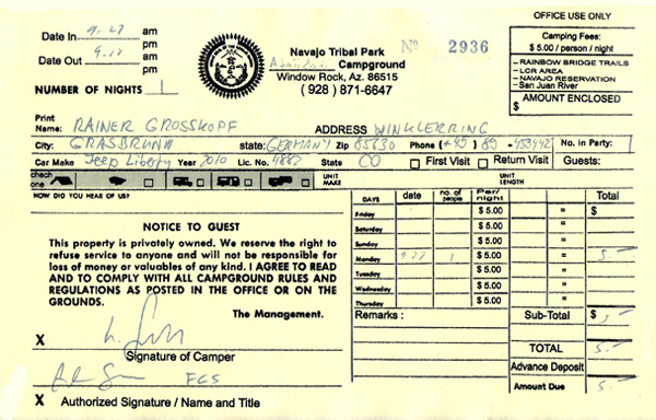
I drove to the Visitor Center in Cameron to get the necessary permits. I wanted to drive to an area that was not a designated tourist destination and I also planned to stay there over night. First I went to the Navajo Chapter House in Cameron, but I was referred to the Visitor Center. The Navajo in the Visitor Center was very friendly and interested, but he had no idea where I planned to go. He went for another 2 colleagues, and together they listened to me closely, wondering where I planned to go. I showed them on my maps, created with DeLorme, where I intended to drive and that the Adeii Eechii Cliffs would be my final destination. They had never heard the name before and could also not tell me how to correctly pronounce it. However, on the maps they could see my planned route and we all went out of the door in front of the Visitor Center, because one could see the Cliffs in the far distance east of us. Now they were happy and we only had to solve the problem what place should be mentioned in the permits. Finally, the Navajo simply wrote down the name of my records about Adeii Eechii Cliffs. Now I got a backcountry permit for 2 days (10 US$) and a camping permit (5 US$ ) that allowed me to stay at the Cliffs over night.
I was pleased that I now had all the permits I needed to legally perform my tour. The stories of encounters with aggressive Navajos had me worried somewhat, and I felt at least "legally" on the safe side.
Many roads are leading to the Cliffs
The following map, created with DeLorme, shows the different routes to the Adeii Eechii Cliffs suggested by various people which also drove along these routes.
Starting from Highway US-160 south of Tuba City, the originally published route (yellow flags) leads for about 20 miles on unpaved back roads to the Cliffs at waypoint AEC18. So far I only knew the cross-link from Highway US-160 to Highway US-89, where I drove in March 2010. The road is a bit rough, but at dry weather also suitable for passenger cars.
The light blue flags mark the entrance from Highway US-89, which is shorter up to waypoint ALT02 or AEC05 than the yellow route starting in Tuba City and also in much better shape.
During my visit in March 2010, I had the impression that the south leading track (yellow flags) soon became sandy and was suitable only for 4WD, starting shortly after the point where yellow and light blue tracks unite. However, I've never driven this route entirely.
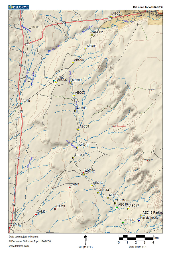
I took the route with the red flags starting in Cameron. This is definitely the shortest of the routes and it was in excellent condition, except a very short part. Even after the red and yellow tracks had united, the road was still very good. I drove on this easy road to the green flag at AEC20 because a few interesting hoodoos were visible.
However, the route to the Adeii Eechii Cliffs leaves this good track at Waypoint AEC16 and soon becomes very sandy - I would not go there without 4WD. At least around Waypoint AEC18 you should park your car and explore the area on foot.
The dark blue flag marks the house of the Navajo, which is above the cliffs where probably most of the area at the Cliffs as well as the proposed car park can be viewed.
Here you can download (.gpx) the waypoints of the various routes.
The Cameron Route
Having got the permits, I drove from the Visitor Center in Cameron a bit to the north on Highway US-89. Just after crossing the Little Colorado River one should make a right onto a relatively good unpaved road. But immediately you have to turn left and don’t follow the signed IR 6730 that goes south along the Little Colorado River.
Pretty soon I came to the yellow route and followed it in southern direction. Most of the road was in good shape and easy to drive. When the arrow on my GPS pointed to the left, telling me to leave the main track and follow a sandy spur road, I ignored this and continued straight forward on the good track. On the horizon I saw a couple of hoodoos rising in the sky and I wanted to get closer and investigate that area.
The hoodoos at waypoint AEC20 were quite nice but it was not worthwhile staying for photography due to the flat light at this time of the day. I drove back and took the sandy spur road leaving at waypoint AEC16. From now on the track remained sandy all the time and I had to pass deep sand in some places. Without 4WD you should not drive there.
Just before reaching the targeted car park in front of the Cliffs, the road led down a sandy hill. About 500 meters away I saw a house (blue flag) with a few parked cars beside. On the one hand, I would not drive down the sandy slope as I was concerned to have problems coming up again, on the other hand it was not far to the Cliffs. However, the main reason why I turned around and parked my car out of sight of the house, were these stories of encounters with hostile Navajos.
Indeed, I had all the necessary permits, but why should I draw the attention of the Navajos living here to me and my car, if I could avoid it easily. Perhaps the residents of the house could feel disturbed in their self-imposed solitude when I park my car more or less in their front yard. I was not keen of any encounter with Navajos and just wanted to remain unobserved in order to do my photography undisturbed.
From my chosen car park behind the sand hill and out-of-sight from the Navajo house, it was about 1 mile to hike to the Cliffs. In fact I could hike in different directions, as the cliffs form a great half circle with a radius of approximately 1 mile.
In south-eastern direction, even from this distance I could see some interesting sandstone formations - so I went in that direction. On my hike to the cliffs I always tried to stay outside the range of view from the house, because I did not want to be noticed and wanted to be left alone if possible.
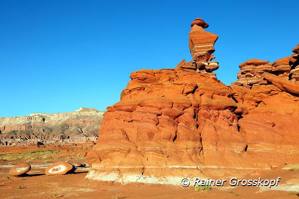
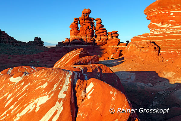
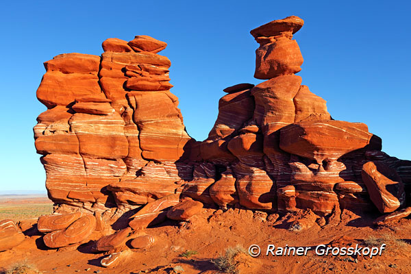
Red Canyon
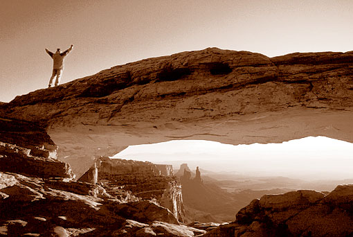
There were wonderful photo opportunities in the chosen area, and lots of motifs left no time for me to intensively investigate other areas. Therefore, I could unfortunately only visit a small part of the Cliffs, but an area with some very interesting and well-known motifs.
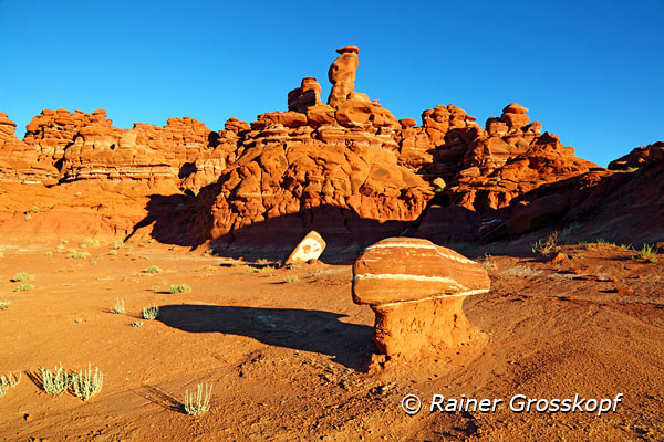
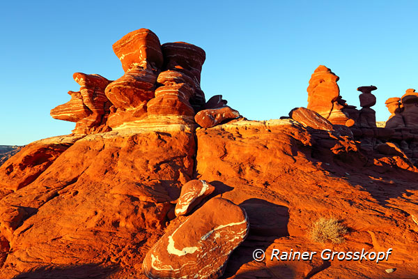
The warm light of the setting sun was even intensifying the color of the red sandstone - probably one reason for the undercover name “Red Canyon” for this area. However, it was obvious that some of the scenes should be taken at sunrise at its best - no problem, because I stayed here overnight.
After sunset I went back to my car and still enjoyed the evening with a starlit sky. I felt fine and unobserved, because one should not be able to see the light in my car from the Navajo house. However, I could see the lights of Cameron in the distance, because it is as the bird flies only about 10 miles away. After a few illegal beers - no alcohol is allowed on the reservation - I went to bed early because at dawn I wanted to be back at the Cliffs.
At sunrise I went back to the same area for location scouting, so finally I did not see much from other areas of the Adeii Eechii Cliffs.
There is still so much to explore - reason enough for another visit at a future trip. When the light became too bright and hard, I stopped photographing and went back to the car. Then I drove back to Cameron without any problems.
>> more pictures
|