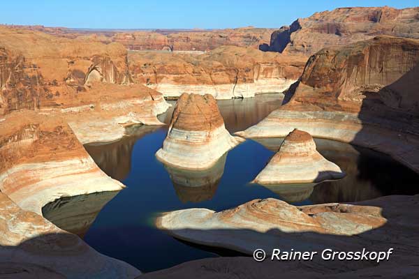
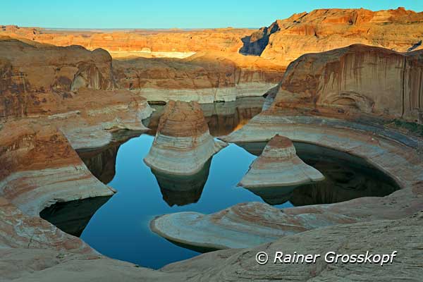
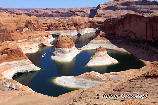
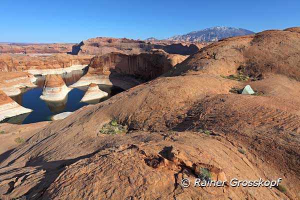
In September 2010, I hiked in a strenuous day trip from Hole-in-the-rock road to Reflection Canyon and back again. Unfortunately, I did not consider the relatively high water level of Lake Powell, whereby the Canyon was not so photogenic because the snakelike form of the canyon was not so obvious. However, I decided to come back one day at significantly lower water level, but then with a tent to spend the night at the viewpoint.
Planning
Because the first hike got me down with comparatively lightweight luggage - I went there and back in one day - the tour with heavy luggage (tent, sleeping bag, etc.) had to be well planned. The most important point is to have enough water, because I will need a gallon of water per day. But I did not want to carry 2 gallons with me, because the backpack would be heavy enough with 1 gallon for the first day. I really could not use more pounds on my shoulders.
From my first visit, it was clear to me that it was impossible to get water from Reflection Canyon. The canyon walls are relatively steep and slippery slick rock and it would be rather dangerous to try to get down to the water. So I intensively studied the area in Google Earth, and finally I thought I had found a rather flat access to the shores of Lake Powell about one mile south from my view point. Nevertheless, I planned to take a 15 m long cloth-line with me, if I could not get close enough to the water.
Water level
There is a website where you can see the Lake Powell daily water levels for the recent years. It is rather obvious from these graphs that the lowest water level will happen around end of April, before the melting snow will lead to increasing water level. Since end of 2012 the water level was already strikingly low, it could be foreseen that in April 2013 the water level of Lake Powell would be as low as it has not been for some years. The water level of Lake Powell would be approximately 40 feet lower than during my last visit. I wanted to visit anyway the Southwest of the United States in spring 2013, and hence, it was clear, that I then would try to realize my plan of a further hike to Reflection Canyon.
The hike
My rental car was a Jeep Patriot, which has a good height clearance and also 4WD. Not my dream car, but suitable for the Hole-in-the-rock road. I wanted to start again at the trailhead to the Llewellyn Gulch, and it is located in an area where the Hole-in-the-rock road is quite rough, and at least a vehicle with good height clearance is necessary.
I had obtained a permit by the BLM to spend two nights in the area around the trailhead. The first night I would sleep in my car, and the next night I hoped to spend at Reflection Canyon. The permit is free of charge and likely used by BLM to get an overview about the activities around Hole-in-the-rock road.
In the morning, around 9 AM I started my hike with estimated 30 pounds on my back, including one gallon of water. Sunny weather with about 82 F was expected for the next days, perhaps somewhat too warm for hiking, although it was only end of April. This time I followed a trail to the entry into Llewellyn Gulch at the beginning, because the trail was well recognizable, and I had not to find my own route through the sage brush covered terrain. At my first hike, I did not know about the trail.
Even after I had passed the Llewellyn Gulch, there was a further trail, which I followed awhile until the trail led east, probably to Cottonwood Canyon. From then on, I followed my waypoints and arrived with many pauses after approximately five to six hours at my goal, the view point on the Reflection Canyon.
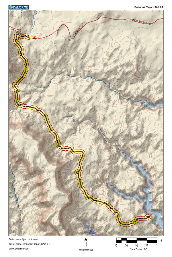
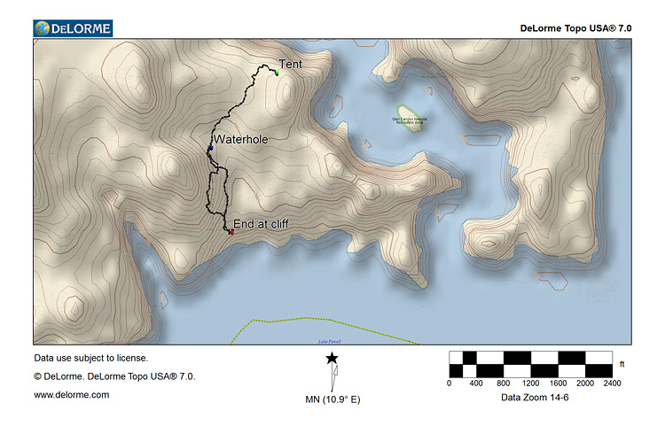
The following map was created with DeLorme Topo USA 7.0 and shows my hike from the parked car to the view point. You can also download the track (.gpx) of my hike.
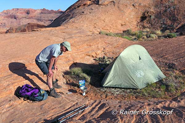
Immediately, I could see the distinct difference in the water level in comparison to my first visit, because much more of the rocks was sticking out of the water, emphasizing much better the snakelike line of the Canyon. I took a few photos, built up my tent in a small rock hollow filled with sand, and decided once to fill up my water supply.
I had left about one liter (33 fluid ounces) of Gatorade and a little less than one liter of water. I would need the water to prepare my dinner (freeze-dried chicken enchilada), and if something was left, for my coffee the next morning. The Gatorade I would probably drink in the course of the day, because it was only afternoon.
Unattainable water at Lake Powell
I followed my route planned with Google Earth to the approximately one mile remote shores of Lake Powell. The Reflection Canyon is a side canyon to Lake Powell, and on the lake itself, the banks should be flat enough to get to the water. Then the great disappointment - I came to an edge of a rock cliff, where the terrain was abruptly falling down for about 60 ft.
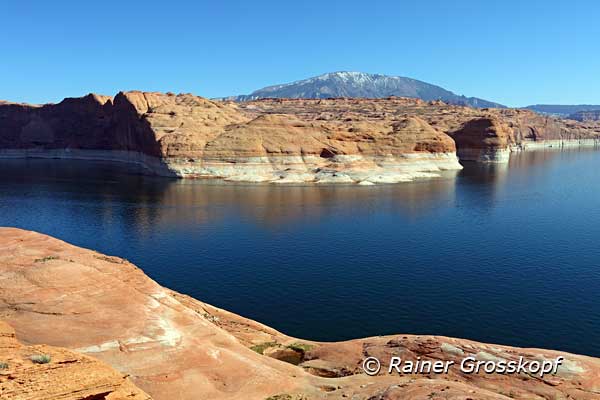
As far as I could see, there was no chance to get down the rim to the lower rock level. But even if I could get down to the lower lying rocky plateau, I would still be much too high, to get to the water in Lake Powell. That was the disadvantage of the significantly lower water level.
I realized that there was no chance to get any water from Lake Powell to fill up my water supplies. Strange enough, that I did not feel uneasy or panicked. But I had to think of the legend about Dead Horse Point. Dead Horse Point is a viewpoint in the Canyonlands, high above the Colorado River. The view point had its name allegedly therefore, that some thirsty horses which could not find any water on the high mesa, desperately jumped down because they saw the water of the Colorado River below. However, I had no intention to do it like the horses.
The black water hole
I slowly went back to my tent and though about what to do. I could instantly dismount my tent, and start hiking back a part of the route before nightfall, because the temperatures would be moderate. The strenuous hike for 5 to 6 hours during daylight at temperatures of 82 F without sufficient water would be a risky thing. For my dinner today I still needed water � I have not ate much today, and I was already thirsty again. There would not remain much water for the hike back.
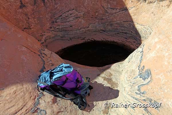
I was already rather near to my tent, when I suddenly saw a black hole in a shady, dark corner of the rocks filled with water. There was enough water in it, and I could not even see the ground. I had no idea how long the water was already in the hole, or who or what had drunk already out of it.
The following map was created with DeLorme Topo USA 7.0 and shows my route trying to find access to Lake Powell to fill up my water supplies, and also the water hole I found on my way back to the tent. You never know what it is good for, hence I give the coordinates of the water hole: 37.185587,-110.923215
Voluntarily, I would not have taken drinking water from this hole, but what was the alternative? So I filled my water bag with about 3 liters (100 fluid ounces) and threw some Micropur tablets for water disinfection into it. Nevertheless, I would boil the water in any case.
But for the time being the world was back in order again, I had water! Back at the tent I greedily drank big gulps of my Gatorade, without bad conscience. Then I boiled water for tea and dinner.
I only had to go a few steps away from my tent site to have a view at the Reflection Canyon. From time to time I took some photos in the late afternoon light.